• Habitation Céron garden

    Le Prêcheur

    Presentation

    Le Prêcheur shares the northern tip of Martinique with Grand’Rivière. The town grew in part thanks to its proximity to Saint-Pierre, the island’s former capital. Today, it’s best known for its striking black sand beaches—remnants of the volcanic legacy of nearby Mount Pelée. Sunset at Anse Couleuvre is simply unforgettable. Le Prêcheur also offers a range of hiking trails, including one of the island’s most iconic routes: a several-hour trek through untouched wilderness that links the town to Grand’Rivière.

  • History

    Le Prêcheur is a commune located at the northern tip of Martinique, just north of Saint-Pierre and west of Grand’Rivière.

    Its name comes from a rock formation that once resembled a preacher in a pulpit—sadly lost during the eruption of Mount Pelée. Close to Saint-Pierre and Le Carbet, the first towns settled by colonists, Le Prêcheur became one of the island’s earliest parishes. It was established in the 1640s, with a church built in 1644 where notable figures such as Father Du Tertre and Father Labat officiated.

    The church once housed a bell gifted by Louis XIV in 1712. After the devastating 1902 eruption, only the bell tower remained—now the oldest in Martinique and listed as a Historic Monument.

    The Indigenous peoples who originally inhabited the area were quickly displaced toward the Atlantic coast, before being permanently driven out or exterminated.

    Gradually, the parish became more populated, and a sugar mill was built in 1658. It wasn’t until 1680—forty years after its establishment—that a proper town center emerged.

    In the 18th century, the church had to be rebuilt, though technical challenges made it impossible to construct stone bell towers above the choir.

    Throughout the 18th and 19th centuries, despite the presence of a sugar mill, Le Prêcheur remained focused on fishing and agriculture. Local produce was transported to Saint-Pierre, then the island’s capital.

    In 1902, the town was severely affected by the eruption of Mount Pelée. Many buildings were destroyed, and residents were relocated to central communes. It wasn’t until the 1920s that Le Prêcheur began to regain its appeal.

    In 1930, under the leadership of Asthon Tardon—father of Manon and Raphaël Tardon—the Byzantine-style church and town hall were rebuilt.

    The town slowly repopulated after the 1950s.

    Le Prêcheur was also home to Françoise d’Aubigné, later known as Madame de Maintenon, who lived there from age 3 to 10. She would go on to marry Louis XIV. Legend has it she retained a deep affection for the place, which she passed on to the king—who then intensified sugarcane cultivation on the island. She is said to have returned to Le Prêcheur several times, deeply marked by her childhood memories.

    Economy

    True to its roots, Le Prêcheur remains centered on fishing and agriculture. Though less frequented by tourists due to its remote location, it boasts several remarkable sites: the black sand beaches of Anse Céron and Anse Couleuvre, the historic Habitation Céron, and the 1644 bell tower.

    Nature lovers will enjoy the 15-kilometer hiking trail that links Le Prêcheur to Grand’Rivière, winding through pristine landscapes.

    Neighborhoods

    The main districts of the commune include Anse Belleville, Abymes, Bourg, Charmeuse, and Pointe Lamarre.

List of places to visit

beaches

  • Anse Belleville

    Anse Belleville is a Le Prêcheur beach located between downtown and Anse Céron.

    Like its sister beaches, its sand is black, due to the eruptions of Montagne Pelée. The beach is frequented…

  • Anse Céron

    Anse Céron, in the commune of Prêcheur, is well worth a visit for its grey-black volcanic sand.

    The beach is bordered by coconut and grape trees, and there is a great deal of vegetation. The water is…
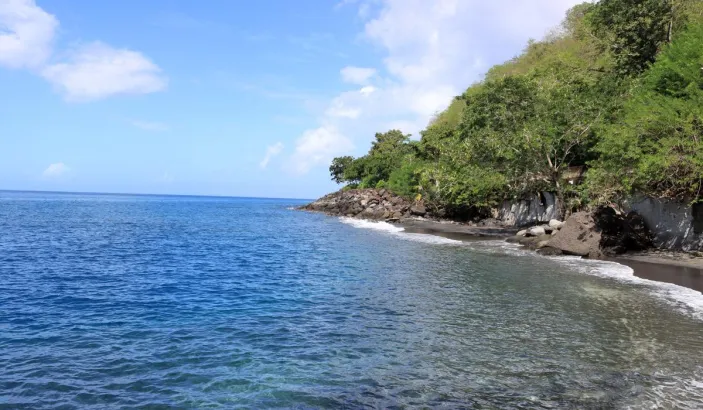
  • Anse Couleuvre

    Anse Couleuvre is two beaches at the foot of impressive cliffs. The vegetation is so extensive that some consider it to be a wild beach. Coconut palms on the beach provide welcome shade.

    The…

  • Anse Lévrier

    If you're a keen hiker, Anse Lévrier is the place for you, as it's only accessible after a walk through the abundant nature of the north of the island. Grab your walking shoes (especially not white ones,…

  • Plage la Charmeuse

    Plage la Charmeuse is the southernmost beach of Le Prêcheur and therefore the closest to the town. It is also a black sand beach, like all the others in the municipality.

    It is little…

historic sites

  • Habitation Céron

    Habitation Ceron is a former sugar factory built in the early days of colonization in 1685, located in the town of Prêcheur. It was a place of growing coffee, cocoa, cassava and banana, but…

islets

  • Îlet la Perle

    Îlet La Perle is the only islet of Prêcheur. It's a great spot to do the diving. It is located 2,800 meters from the coastline in the Prêcheur in the Martinique passage off the…

More information

  • Le Prêcheur logo
    Le Prêcheur
    Mayor:
    Marcellin Nadeau
    Zip code:
    97250
    Number of inhabitants:
    1,474 hab. (2022)
    Surface area:
    29.92 km² (11.55 m²)